
Autonomous Space Robotics Lab
Devon Island
Rover Navigation Dataset
Long-range localization data
[Back] [Overview] [Details] [File Format] [Usage] [Downloads] [Tools]
Overview
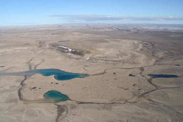
 The long-range localization dataset consists
of 3D lidar scans, 3D orbital maps, and ground-truth rover positions acquired from field tests at a
Mars/Moon analogue site on Devon Island, Nunavut (75°22'N and
89°41'W).
Data Collection Details
Lidar Scans and Panoramic Images Ground-TruthGround-truth positions of the lidar scan locations were obtained from a Garmin GPSMAP 76CSx. After averaging GPS measurements for several minutes at each scan location, the standard deviation of position measurements was estimated to be 1m. The date and time of each scan are given in the following table. Each scan took at least 30 minutes to collect so we report the time that the scan was started in Central Daylight Time (CDT). The start times are accurate to within 30 minutes.
|
||||||||||||||||||||||||||||||||||||||||||||||||||||||||||||||||||||||||||||||||||||||||||||||||||||||||||||||||||
Orbital Maps
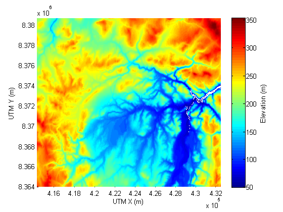
Orbital maps of Devon Island were obtained on December 11, 2009 from Geobase---a repository of up-to-date geospatial data for Canadian territory maintained by the Canadian Council on Geomatics. The maps were projected from North American Datum 1983 (NAD83) latitude/longitude coordinates to the Universal Transverse Mercator (UTM) coordinate system using the commercial program Global Mapper. The elevation data in the maps is expressed in the Canadian Geodetic Vertical Datum 1928 (CGVD28). Two maps are provided: |
||||||||||||||||||||||||||||||||||||||||||||||||||||||||||||||||||||||||||||||||||||||||||||||||||||||||||||||||||
File Format and DescriptionThe dataset is organized into two subsets:
Lidar Scan Point CloudFilename: A[Scan #].txt
where the coordinate frame origin is at the laser center, the x-axis points East, the y-axis points North, the z-axis points up, and the reflected beam's intensity ranges from 0 (weak) to 255 (strong). Lidar Scan Panoramic ImageFilename: A[Scan #].png Lidar Scan Ground-TruthFilename: groundtruth.txt
Orbital MapsFilenames: "mapHiRes.txt", "mapLoRes.txt"
|
||||||||||||||||||||||||||||||||||||||||||||||||||||||||||||||||||||||||||||||||||||||||||||||||||||||||||||||||||
Data UsageMatching Scans To Orbital MapsLidar scans can be matched to the orbital maps to globally localize the lidar scan origin. As given, the maps are much larger than any individual scan. It may therefore be of interest to trim the maps (see plotPointsOnMap.m) before attempting to match. Scans 24, 25 and 29 are not fully contained by the high-resolution orbital map ( eg. try executing plotPointsOnMap(24,'mapHiRes') ). Data for this area of Devon Island is not currently available from Geobase. Plotting Scan Points On ImagesScan points can be plotted on the panoramic images (see plotPointsOnImage.m) knowing the lidar's camera parameters. The horizontal and vertical fields of view of each image are respectively 360° and 45.5°. East (0°) is the rightmost pixel. The middle vertical pixel is zero degrees, with the exception of the following scans, which were tilted:
|
||||||||||||||||||||||||||||||||||||||||||||||||||||||||||||||||||||||||||||||||||||||||||||||||||||||||||||||||||
DownloadsThe dataset may be downloaded as a zip archive from ftp://asrl3.utias.utoronto.ca/Devon-Island-Rover-Navigation/. Lidar Scans | compressed size: 1300MB, extracted size: 4480MB Orbital Maps | compressed size: 33MB, extracted size: 312MB Important note: The dataset provides ftp download links. Some browsers no longer enable ftp links by default and you need to change the settings if you want to download using the browser. Using the wget command is an alternative to avoid the browser. |
||||||||||||||||||||||||||||||||||||||||||||||||||||||||||||||||||||||||||||||||||||||||||||||||||||||||||||||||||
Access ToolsThe following tools are provided for the convenience of dataset users. Run them in the dataset's root directory. Matlab Scripts
|
[Back] [Top] [Overview] [Details] [File Format] [Usage] [Downloads] [Tools]
 Lidar
scans and panoramic images were
acquired at 37
different locations on Devon Island with an Optech ILRIS3D-ER. The
point clouds from these 360° scans contain millions of points
spread out over a maximum range of about 1.5km with centimeter-scale
position accuracy. A camera on the lidar also allowed panoramic images
to be collected. Before each scan, the lidar was leveled with a
two-axis bubble level to an accuracy of about 1 degree for one standard
deviation. To obtain the heading of the lidar with respect to the
Easting, a target was setup about 100 metres away and scanned. Knowing
the GPS locations of the target and lidar, the orientation of the lidar
could be determined with an accuracy of 1 degree for one standard
deviation.