
Autonomous Space Robotics Lab
Devon Island
Rover Navigation Dataset
[Overview] [Summary] [Credits] [Acknowledgements]
Overview
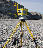
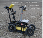
The Devon Island Rover Navigation Dataset is a collection of data gathered at a Mars/Moon analogue site on Devon Island, Nunavut (75°22'N and 89°41'W) suitable for robotics research. The dataset is split into two parts. The first part contains rover traverse data---stereo imagery, sun vectors, inclinometer data, and ground-truth position information from a differential global positioning system (DGPS) collected over a ten-kilometer traverse. The second part contains long-range localization data---3D laser range scans, image panoramas, digital elevation models, and GPS data useful for global position estimation. All images are available in common formats and other data is presented in human-readable text files. To facilitate use of the data, Matlab parsing scripts are included.
[Download Google Earth overview]
Summary
- Rover engineering sensor data collected over a ten-kilometer traverse on Devon Island
- Full color, 1280x960 stereo image pairs captured approximately every 20 centimeters
- Sun vectors captured by a space-grade sun sensor
- Inclinometer data
- Ground truth position information from differential GPS
- Platform orientation (estimated from sun sensor and inclinometer data) available at 23 locations along the traverse
Long-range Localization Data

- Panoramic, long-range lidar scans (up to 1.5 kilometers) acquired at 37 different locations on Devon Island
- Panoramic images captured at each scan location
- Gps data and ground-truth orientation provided for each scan
- Orbital digital elevation models of the area provided in an easily-parsible format
Credits
This dataset was the work of Paul Furgale, Pat Carle, John Enright, and Tim Barfoot.
If you use the data provided by this website in your own work, please use the following citation:
Furgale P T, Carle P, Enright J, and Barfoot T D. “The Devon Island Rover Navigation Dataset”. International Journal of Robotics Research, 2012. Manuscript #IJR-10-0896, accepted on September 27, 2011.
Acknowledgements
The collection and processing of this data would not have been possible without the help of many people and we would like to thank some of them here. Funding for our field trials on Devon Island was provided by The Canadian Space Agency's Canadian Analogue Research Network (CARN) program [grant CARN-08-01]. The Natural Sciences and Engineering Research Council of Canada (NSERC) funded the remaining work. The Mars Institute and the Haughton-Mars Project provided infrastructure on Devon Island. Members of the communities of Resolute Bay, Grise Fjord, and Pond Inlet acted as guides, and protected us and our equipment from polar bears. Tom Lamarche from the Canadian Space Agency helped with our field testing. The authors would like to thank Mr. Doug Sinclair of Sinclair Interplanetary for the donation of a SS-411 Digital Sun Sensor. Finally, at the University of Toronto Institute for Aerospace Studies, Konstantine Tsotsos and Peter Miras provided logistical support, and Rehman Merali pitched in during assembly of our pushcart rover.
